SETUP: Iceland0_MARBL_2024
This notebook configures the outermost ROMS grid and associated forcing files for the Iceland0_MARBL_2024 configuration.
Grid generation: Build a coarse SRTM15-based grid and vertical coordinates using
roms_tools.Grid.Tides: Generate TPXO-based tidal forcing files (
*_tides.nc).Surface forcing: Create ERA5-based physical forcing and UNIFIED BGC surface climatologies.
Initial conditions: Interpolate GLORYS + UNIFIED fields to the ROMS grid.
Boundaries: Build GLORYS-based physical and UNIFIED BGC boundary forcing.
Child grid: Define and save the nested Iceland1 grid and associated nesting metadata.
Run the notebook top-to-bottom when (re)creating the full set of input files for Iceland0.
ROMS-TOOLS setup for Iceland0_MARBL_2024
First step is to set up the outer grid using ROMS-TOOLS and save the grid file.
import xarray as xr
from roms_tools import Grid
/home/x-uheede/.conda/envs/romstools-test/lib/python3.13/site-packages/tqdm/auto.py:21: TqdmWarning: IProgress not found. Please update jupyter and ipywidgets. See https://ipywidgets.readthedocs.io/en/stable/user_install.html
from .autonotebook import tqdm as notebook_tqdm
project='/anvil/projects/x-ees250129/x-uheede/INPUT_files/Iceland0_MARBL_2024/'
datasets='/anvil/projects/x-ees250129/Datasets/'
model_name='Iceland0'
child_name='Iceland1'
grid_path='/anvil/projects/x-ees250129/x-uheede/MATLAB/setup_s2r_phys+bgc/1.Make_grid/Iceland0_grid_MAT.nc'
import dask
dask.config.set(
scheduler="threads", # Use multi-threading
n_workers=10, # Number of threads; adjust as needed
)<dask.config.set at 0x14c50709b890>%%time
grid = Grid(
nx=512, # number of grid points in x-direction
ny=512, # number of grid points in y-direction
size_x=1280, # domain size in x-direction (in km)
size_y=1280, # domain size in y-direction (in km)
center_lon=-25, # longitude of the center of the domain
center_lat=63, # latitude of the center of the domain
rot=-20, # rotation of the grid (in degrees)
topography_source={
"name": "SRTM15",
"path":datasets+"SRTM15/SRTM15_V2.6.nc"},
N=60, # number of vertical layers
verbose=True,
)2026-03-16 18:31:30 - INFO - === Creating the horizontal grid ===
2026-03-16 18:31:31 - INFO - Total time: 0.392 seconds
2026-03-16 18:31:31 - INFO - ================================================================================================
2026-03-16 18:31:31 - INFO - === Deriving the mask from coastlines ===
2026-03-16 18:31:31 - INFO - Total time: 0.660 seconds
2026-03-16 18:31:31 - INFO - ================================================================================================
2026-03-16 18:31:31 - INFO - === Generating the topography using SRTM15 data and hmin = 5.0 meters ===
2026-03-16 18:31:32 - INFO - Reading the topography data: 0.069 seconds
2026-03-16 18:31:32 - INFO - Regridding the topography: 0.176 seconds
2026-03-16 18:31:32 - INFO - Domain-wide topography smoothing: 0.030 seconds
2026-03-16 18:31:35 - INFO - Local topography smoothing: 2.751 seconds
2026-03-16 18:31:35 - INFO - Total time: 3.491 seconds
2026-03-16 18:31:35 - INFO - ================================================================================================
2026-03-16 18:31:35 - INFO - === Preparing the vertical coordinate system using N = 60, theta_s = 5.0, theta_b = 2.0, hc = 300.0 ===
2026-03-16 18:31:35 - INFO - Total time: 0.003 seconds
2026-03-16 18:31:35 - INFO - ================================================================================================
CPU times: user 4.28 s, sys: 215 ms, total: 4.5 s
Wall time: 4.58 s
import matplotlib.pyplot as plt
cf=plt.contourf(grid.ds.mask_rho)
plt.colorbar(cf)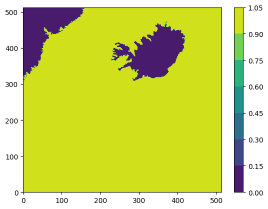
grid.plot()
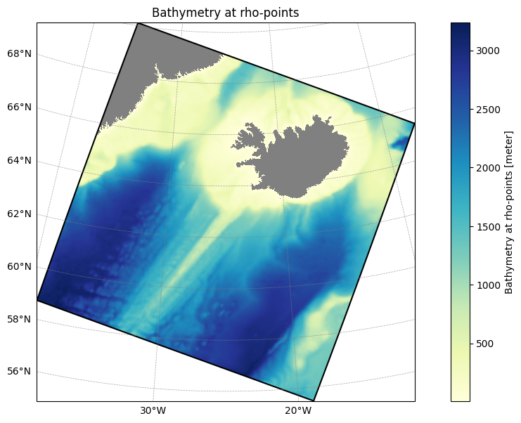
filepath = project+model_name+'_grid.nc'Step 1: Grid Creation
Builds and writes the model grid file.
grid.save(filepath)2025-10-03 14:57:16 - INFO - Writing the following NetCDF files:
/anvil/projects/x-ees250129/x-uheede/INPUT_files/Iceland0_MARBL_2024/Iceland0_grid.nc
[PosixPath('/anvil/projects/x-ees250129/x-uheede/INPUT_files/Iceland0_MARBL_2024/Iceland0_grid.nc')]tpxo_path = datasets+"TPXO/TPXO10.v2/"
tpxo_dict = {
"grid": tpxo_path + "grid_tpxo10v2.nc",
"h": tpxo_path + "h_tpxo10.v2.nc",
"u": tpxo_path + "u_tpxo10.v2.nc",
}Next, we set up tidal forcing:
from roms_tools import TidalForcingfrom datetime import datetimemodel_reference_date = datetime(2000, 1, 1)
tidal_forcing = TidalForcing(
    grid=grid,
    source={"name": "TPXO", "path": tpxo_dict},
    ntides=15,  # Number of constituents to consider <= 15. Default is 10.
    model_reference_date=model_reference_date,  # Model reference date. Default is January 1, 2000.
    use_dask=True
)
2025-10-03 14:57:20 - INFO - Applying 2D horizontal fill to the source data before regridding.
2025-10-03 14:57:23 - INFO - Applying 2D horizontal fill to the source data before regridding.
2025-10-03 14:57:23 - INFO - Applying 2D horizontal fill to the source data before regridding.
2025-10-03 14:57:24 - INFO - Applying 2D horizontal fill to the source data before regridding.
filepath = project+model_name+"_tides.nc"Step 2: Tidal Forcing Creation
Builds and writes the tidal forcing file.
%time tidal_forcing.save(filepath)2025-10-03 14:57:25 - INFO - Writing the following NetCDF files:
/anvil/projects/x-ees250129/x-uheede/INPUT_files/Iceland0_MARBL_2024/Iceland0_tides.nc
[########################################] | 100% Completed | 7.69 ss
CPU times: user 3min 15s, sys: 1.28 s, total: 3min 17s
Wall time: 7.8 s
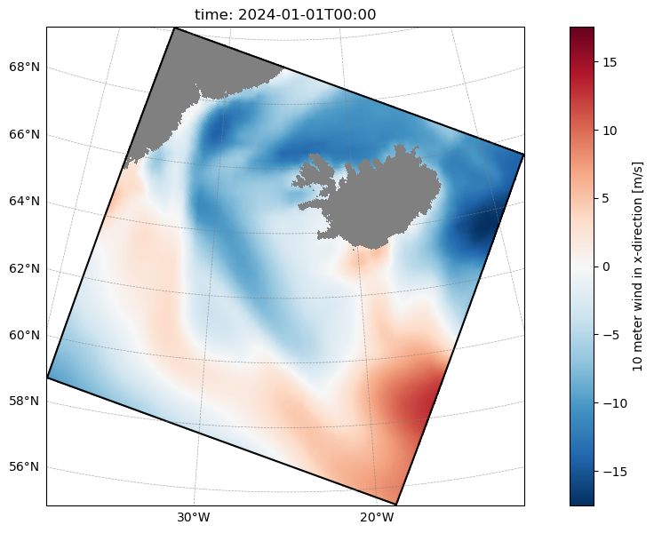
[PosixPath('/anvil/projects/x-ees250129/x-uheede/INPUT_files/Iceland0_MARBL_2024/Iceland0_tides.nc')]For the surface forcing, we use ERA5 plus the unified BGC dataset
from roms_tools import Grid, SurfaceForcingstart_time = datetime(2024, 1, 1)
end_time = datetime(2024, 6, 1)surface_forcing_kwargs = {
"grid": grid,
"start_time": start_time,
"end_time": end_time,
"type": "physics",
"model_reference_date": datetime(2000, 1, 1), # this is the default
}%%time
surface_forcing = SurfaceForcing(
**surface_forcing_kwargs,
source={"name": "ERA5"},
use_dask=True,
)2025-10-03 14:57:33 - INFO - No path specified for ERA5 source; defaulting to ARCO ERA5 dataset on Google Cloud.
2025-10-03 14:59:11 - INFO - Data will be interpolated onto the grid coarsened by factor 2. Remember to set `interp_frc = 1` in your `bulk_frc.opt` ROMS option file.
2025-10-03 14:59:11 - INFO - Applying 2D horizontal fill to the source data before regridding.
2025-10-03 14:59:14 - INFO - Applying 2D horizontal fill to the source data before regridding.
CPU times: user 2min 59s, sys: 8.2 s, total: 3min 8s
Wall time: 2min 35s
surface_forcing.plot("uwnd", time=0)[########################################] | 100% Completed | 303.47 ms
#cesm_bgc_path = "/global/cfs/projectdirs/m4746/Datasets/CESM_REGRIDDED/CESM-surface_lowres_regridded.nc"
unified_bgc_path = datasets+"UNIFIED/BGCdataset.nc"
%%time
unified_bgc_surface_forcing = SurfaceForcing(
grid=grid,
start_time=start_time,
end_time=end_time,
source={"name": "UNIFIED", "path": unified_bgc_path, "climatology": True},
type="bgc",
use_dask=True,
)2025-10-03 15:00:12 - INFO - Data will be interpolated onto the grid coarsened by factor 2. Remember to set `interp_frc = 1` in your `bgc.opt` ROMS option file.
2025-10-03 15:00:12 - INFO - 2D horizontal fill is skipped because source data already contains filled values.
CPU times: user 142 ms, sys: 11 ms, total: 153 ms
Wall time: 301 ms
filepath = project+model_name+"_surface_forcing2024.nc"Step 3: Surface Forcing Creation
Builds and writes the physical surface forcing file.
%time surface_forcing.save(filepath)2025-10-03 15:00:14 - INFO - Writing the following NetCDF files:
/anvil/projects/x-ees250129/x-uheede/INPUT_files/Iceland0_MARBL_2024/Iceland0_surface_forcing2024_202401.nc
/anvil/projects/x-ees250129/x-uheede/INPUT_files/Iceland0_MARBL_2024/Iceland0_surface_forcing2024_202402.nc
/anvil/projects/x-ees250129/x-uheede/INPUT_files/Iceland0_MARBL_2024/Iceland0_surface_forcing2024_202403.nc
/anvil/projects/x-ees250129/x-uheede/INPUT_files/Iceland0_MARBL_2024/Iceland0_surface_forcing2024_202404.nc
/anvil/projects/x-ees250129/x-uheede/INPUT_files/Iceland0_MARBL_2024/Iceland0_surface_forcing2024_202405.nc
/anvil/projects/x-ees250129/x-uheede/INPUT_files/Iceland0_MARBL_2024/Iceland0_surface_forcing2024_202406.nc
[########################################] | 100% Completed | 147.59 s
[########################################] | 100% Completed | 139.10 s
[########################################] | 100% Completed | 162.77 s
[########################################] | 100% Completed | 155.81 s
[########################################] | 100% Completed | 158.63 s
[########################################] | 100% Completed | 519.49 ms
CPU times: user 5h 37min 35s, sys: 2min 16s, total: 5h 39min 52s
Wall time: 14min 4s
[PosixPath('/anvil/projects/x-ees250129/x-uheede/INPUT_files/Iceland0_MARBL_2024/Iceland0_surface_forcing2024_202401.nc'),
 PosixPath('/anvil/projects/x-ees250129/x-uheede/INPUT_files/Iceland0_MARBL_2024/Iceland0_surface_forcing2024_202402.nc'),
 PosixPath('/anvil/projects/x-ees250129/x-uheede/INPUT_files/Iceland0_MARBL_2024/Iceland0_surface_forcing2024_202403.nc'),
 PosixPath('/anvil/projects/x-ees250129/x-uheede/INPUT_files/Iceland0_MARBL_2024/Iceland0_surface_forcing2024_202404.nc'),
 PosixPath('/anvil/projects/x-ees250129/x-uheede/INPUT_files/Iceland0_MARBL_2024/Iceland0_surface_forcing2024_202405.nc'),
 PosixPath('/anvil/projects/x-ees250129/x-uheede/INPUT_files/Iceland0_MARBL_2024/Iceland0_surface_forcing2024_202406.nc')]
filepath = project+model_name+"_bgc_surface_forcing.nc"Step 4: BGC Surface Forcing Creation
Builds and writes the biogeochemical surface forcing file.
%time unified_bgc_surface_forcing.save(filepath)2025-10-03 15:14:16 - INFO - Writing the following NetCDF files:
/anvil/projects/x-ees250129/x-uheede/INPUT_files/Iceland0_MARBL_2024/Iceland0_bgc_surface_forcing_clim.nc
[########################################] | 100% Completed | 203.94 ms
CPU times: user 200 ms, sys: 10.8 ms, total: 211 ms
Wall time: 242 ms
[PosixPath('/anvil/projects/x-ees250129/x-uheede/INPUT_files/Iceland0_MARBL_2024/Iceland0_bgc_surface_forcing_clim.nc')]Next we generate the initial file
from roms_tools import Grid, InitialConditionsfrom datetime import datetimeini_time = datetime(2024, 1, 5)path = datasets+"GLORYS/ICELAND_DOMAIN/2024/cmems_mod_glo_phy_myint_0.083deg_P1D-m_multi-vars_52.50W-2.67E_44.33N-74.42N_1.54-3992.48m_2024-01-05_no_depth_zos.nc"%%time
initial_conditions_with_unified_bgc = InitialConditions(
grid=grid,
ini_time=ini_time,
source={"name": "GLORYS", "path": path},
bgc_source={
"name": "UNIFIED",
"path": unified_bgc_path,
"climatology": True,
}, # bgc_source is optional
model_reference_date=datetime(2000, 1, 1), # this is the default
use_dask=True,
)CPU times: user 10 μs, sys: 1 μs, total: 11 μs
Wall time: 17.4 μs
---------------------------------------------------------------------------
NameError                                 Traceback (most recent call last)
Cell In[5], line 1
----> 1 get_ipython().run_cell_magic('time', '', '\ninitial_conditions_with_unified_bgc = InitialConditions(\n    grid=grid,\n    ini_time=ini_time,\n    source={"name": "GLORYS", "path": path},\n    bgc_source={\n        "name": "UNIFIED",\n        "path": unified_bgc_path,\n        "climatology": True,\n    },  # bgc_source is optional\n    model_reference_date=datetime(2000, 1, 1), # this is the default\n    use_dask=True,\n)\n')

File ~/.conda/envs/romstools-test/lib/python3.13/site-packages/IPython/core/interactiveshell.py:2593, in InteractiveShell.run_cell_magic(self, magic_name, line, cell)
   2591 with self.builtin_trap:
   2592     args = (magic_arg_s, cell)
-> 2593     result = fn(*args, **kwargs)
   2595 # The code below prevents the output from being displayed
   2596 # when using magics with decorator @output_can_be_silenced
   2597 # when the last Python token in the expression is a ';'.
   2598 if getattr(fn, magic.MAGIC_OUTPUT_CAN_BE_SILENCED, False):

File ~/.conda/envs/romstools-test/lib/python3.13/site-packages/IPython/core/magics/execution.py:1448, in ExecutionMagics.time(self, line, cell, local_ns)
   1446 if interrupt_occured:
   1447     if exit_on_interrupt and captured_exception:
-> 1448         raise captured_exception
   1449     return
   1450 return out

File ~/.conda/envs/romstools-test/lib/python3.13/site-packages/IPython/core/magics/execution.py:1412, in ExecutionMagics.time(self, line, cell, local_ns)
   1410 st = clock2()
   1411 try:
-> 1412     exec(code, glob, local_ns)
   1413     out = None
   1414     # multi-line %%time case

File <timed exec>:1

NameError: name 'InitialConditions' is not defined
filepath = project+model_name+"_initial_conditions.nc"Step 5: Initial Conditions Creation
Builds and writes the model initial conditions file.
%time initial_conditions_with_unified_bgc.save(filepath)2025-10-03 15:14:33 - INFO - Writing the following NetCDF files:
/anvil/projects/x-ees250129/x-uheede/INPUT_files/Iceland0_MARBL_2024/Iceland0_initial_conditions.nc
[########################################] | 100% Completed | 190.02 s
CPU times: user 41min 19s, sys: 17min 23s, total: 58min 42s
Wall time: 3min 13s
[PosixPath('/anvil/projects/x-ees250129/x-uheede/INPUT_files/Iceland0_MARBL_2024/Iceland0_initial_conditions.nc')]#glorys_path = [
# datasets+"/GLORYS/ICELAND_DOMAIN/2024/cmems_mod_glo_phy_myint_0.083deg_P1D-m_multi-vars_52.50W-2.67E_44.33N-74.42N_1.54-3992.48m_2024-*_no_depth_zos.nc"]glorys_path = ['/anvil/projects/x-ees250129/cson-forge-data/source-data/GLORYS_GLOBAL/cmems_mod_glo_phy_my_0.083deg_P1D-m_GLOBAL_2024*.nc']
#glorys_path = ['/anvil/projects/x-ees250129/cson-forge-data/source-data/GLORYS_GLOBAL/*.nc']#glorys_path = [
# "/global/cfs/cdirs/m4632/uheede/GLORYS/2024/cmems_mod_glo_phy_myint_0.083deg_P1D-m_multi-vars_52.50W-2.67E_44.33N-74.42N_1.54-3992.48m_2024-01-04_no_depth_zos.nc", # include data from day before start time
# "/global/cfs/cdirs/m4632/uheede/GLORYS/2024/cmems_mod_glo_phy_myint_0.083deg_P1D-m_multi-vars_52.50W-2.67E_44.33N-74.42N_1.54-3992.48m_2024-01-05_no_depth_zos.nc",
# "/global/cfs/cdirs/m4632/uheede/GLORYS/2024/cmems_mod_glo_phy_myint_0.083deg_P1D-m_multi-vars_52.50W-2.67E_44.33N-74.42N_1.54-3992.48m_2024-01-06_no_depth_zos.nc",
# "/global/cfs/cdirs/m4632/uheede/GLORYS/2024/cmems_mod_glo_phy_myint_0.083deg_P1D-m_multi-vars_52.50W-2.67E_44.33N-74.42N_1.54-3992.48m_2024-01-07_no_depth_zos.nc",
# "/global/cfs/cdirs/m4632/uheede/GLORYS/2024/cmems_mod_glo_phy_myint_0.083deg_P1D-m_multi-vars_52.50W-2.67E_44.33N-74.42N_1.54-3992.48m_2024-01-08_no_depth_zos.nc",
# "/global/cfs/cdirs/m4632/uheede/GLORYS/2024/cmems_mod_glo_phy_myint_0.083deg_P1D-m_multi-vars_52.50W-2.67E_44.33N-74.42N_1.54-3992.48m_2024-01-09_no_depth_zos.nc",
# "/global/cfs/cdirs/m4632/uheede/GLORYS/2024/cmems_mod_glo_phy_myint_0.083deg_P1D-m_multi-vars_52.50W-2.67E_44.33N-74.42N_1.54-3992.48m_2024-01-10_no_depth_zos.nc",
# "/global/cfs/cdirs/m4632/uheede/GLORYS/2024/cmems_mod_glo_phy_myint_0.083deg_P1D-m_multi-vars_52.50W-2.67E_44.33N-74.42N_1.54-3992.48m_2024-01-11_no_depth_zos.nc", # include data from day after end time
# "/global/cfs/cdirs/m4632/uheede/GLORYS/2024/cmems_mod_glo_phy_myint_0.083deg_P1D-m_multi-vars_52.50W-2.67E_44.33N-74.42N_1.54-3992.48m_2024-01-12_no_depth_zos.nc",
# "/global/cfs/cdirs/m4632/uheede/GLORYS/2024/cmems_mod_glo_phy_myint_0.083deg_P1D-m_multi-vars_52.50W-2.67E_44.33N-74.42N_1.54-3992.48m_2024-01-13_no_depth_zos.nc",
# "/global/cfs/cdirs/m4632/uheede/GLORYS/2024/cmems_mod_glo_phy_myint_0.083deg_P1D-m_multi-vars_52.50W-2.67E_44.33N-74.42N_1.54-3992.48m_2024-01-14_no_depth_zos.nc", # include data from day before start time
# "/global/cfs/cdirs/m4632/uheede/GLORYS/2024/cmems_mod_glo_phy_myint_0.083deg_P1D-m_multi-vars_52.50W-2.67E_44.33N-74.42N_1.54-3992.48m_2024-01-15_no_depth_zos.nc",
# "/global/cfs/cdirs/m4632/uheede/GLORYS/2024/cmems_mod_glo_phy_myint_0.083deg_P1D-m_multi-vars_52.50W-2.67E_44.33N-74.42N_1.54-3992.48m_2024-01-16_no_depth_zos.nc",
# "/global/cfs/cdirs/m4632/uheede/GLORYS/2024/cmems_mod_glo_phy_myint_0.083deg_P1D-m_multi-vars_52.50W-2.67E_44.33N-74.42N_1.54-3992.48m_2024-01-17_no_depth_zos.nc",
# "/global/cfs/cdirs/m4632/uheede/GLORYS/2024/cmems_mod_glo_phy_myint_0.083deg_P1D-m_multi-vars_52.50W-2.67E_44.33N-74.42N_1.54-3992.48m_2024-01-18_no_depth_zos.nc",
# "/global/cfs/cdirs/m4632/uheede/GLORYS/2024/cmems_mod_glo_phy_myint_0.083deg_P1D-m_multi-vars_52.50W-2.67E_44.33N-74.42N_1.54-3992.48m_2024-01-19_no_depth_zos.nc",
# "/global/cfs/cdirs/m4632/uheede/GLORYS/2024/cmems_mod_glo_phy_myint_0.083deg_P1D-m_multi-vars_52.50W-2.67E_44.33N-74.42N_1.54-3992.48m_2024-01-20_no_depth_zos.nc",
# "/global/cfs/cdirs/m4632/uheede/GLORYS/2024/cmems_mod_glo_phy_myint_0.083deg_P1D-m_multi-vars_52.50W-2.67E_44.33N-74.42N_1.54-3992.48m_2024-01-21_no_depth_zos.nc",
# "/global/cfs/cdirs/m4632/uheede/GLORYS/2024/cmems_mod_glo_phy_myint_0.083deg_P1D-m_multi-vars_52.50W-2.67E_44.33N-74.42N_1.54-3992.48m_2024-01-22_no_depth_zos.nc",
# "/global/cfs/cdirs/m4632/uheede/GLORYS/2024/cmems_mod_glo_phy_myint_0.083deg_P1D-m_multi-vars_52.50W-2.67E_44.33N-74.42N_1.54-3992.48m_2024-01-23_no_depth_zos.nc",
# "/global/cfs/cdirs/m4632/uheede/GLORYS/2024/cmems_mod_glo_phy_myint_0.083deg_P1D-m_multi-vars_52.50W-2.67E_44.33N-74.42N_1.54-3992.48m_2024-01-24_no_depth_zos.nc", # include data from day before start time
# "/global/cfs/cdirs/m4632/uheede/GLORYS/2024/cmems_mod_glo_phy_myint_0.083deg_P1D-m_multi-vars_52.50W-2.67E_44.33N-74.42N_1.54-3992.48m_2024-01-25_no_depth_zos.nc",
# "/global/cfs/cdirs/m4632/uheede/GLORYS/2024/cmems_mod_glo_phy_myint_0.083deg_P1D-m_multi-vars_52.50W-2.67E_44.33N-74.42N_1.54-3992.48m_2024-01-26_no_depth_zos.nc",
# "/global/cfs/cdirs/m4632/uheede/GLORYS/2024/cmems_mod_glo_phy_myint_0.083deg_P1D-m_multi-vars_52.50W-2.67E_44.33N-74.42N_1.54-3992.48m_2024-01-27_no_depth_zos.nc",
# "/global/cfs/cdirs/m4632/uheede/GLORYS/2024/cmems_mod_glo_phy_myint_0.083deg_P1D-m_multi-vars_52.50W-2.67E_44.33N-74.42N_1.54-3992.48m_2024-01-28_no_depth_zos.nc",
# "/global/cfs/cdirs/m4632/uheede/GLORYS/2024/cmems_mod_glo_phy_myint_0.083deg_P1D-m_multi-vars_52.50W-2.67E_44.33N-74.42N_1.54-3992.48m_2024-01-29_no_depth_zos.nc",
# "/global/cfs/cdirs/m4632/uheede/GLORYS/2024/cmems_mod_glo_phy_myint_0.083deg_P1D-m_multi-vars_52.50W-2.67E_44.33N-74.42N_1.54-3992.48m_2024-01-30_no_depth_zos.nc",
# #"/global/cfs/cdirs/m4632/uheede/GLORYS/2024/cmems_mod_glo_phy_myint_0.083deg_P1D-m_multi-vars_52.50W-2.67E_44.33N-74.42N_1.54-3992.48m_2024-01-31_no_depth_zos.nc"
#]from roms_tools import Grid, BoundaryForcingstart_time = datetime(2024, 1, 1)
end_time = datetime(2024, 6, 30)%%time
boundary_forcing = BoundaryForcing(
grid=grid,
start_time=start_time,
end_time=end_time,
boundaries={
"south": True,
"east": True,
"north": True,
"west": True,
},
source={"name": "GLORYS", "path": glorys_path},
type="physics", # "physics" or "bgc"; default is "physics"
model_reference_date=datetime(2000, 1, 1), # this is the default
use_dask=True,
)2026-03-12 18:01:45 - INFO - Using boundary configuration: {'south': True, 'east': True, 'north': True, 'west': True}
2026-03-12 18:01:45 - INFO - Loading full dataset and subsetting spatially (lazy operation)...
2026-03-12 18:02:06 - INFO - Processing 6 month(s) separately to reduce memory usage
2026-03-12 18:02:06 - INFO - Processing month 1/6: 2024-01
[########################################] | 100% Completed | 61.85 s
2026-03-12 18:03:21 - INFO - Processing month 2/6: 2024-02
[########################################] | 100% Completed | 51.50 s
2026-03-12 18:04:25 - INFO - Processing month 3/6: 2024-03
[########################################] | 100% Completed | 54.65 s
2026-03-12 18:05:32 - INFO - Processing month 4/6: 2024-04
[########################################] | 100% Completed | 52.82 s
2026-03-12 18:06:38 - INFO - Processing month 5/6: 2024-05
[########################################] | 100% Completed | 54.93 s
2026-03-12 18:07:46 - INFO - Processing month 6/6: 2024-06
[########################################] | 100% Completed | 60.20 s
CPU times: user 34min 14s, sys: 27min 40s, total: 1h 1min 54s
Wall time: 7min 34s
boundary_forcing.ds.u_south%%time
unified_bgc_boundary_forcing = BoundaryForcing(
grid=grid,
start_time=start_time,
end_time=end_time,
boundaries={
"south": True,
"east": True,
"north": True,
"west": True,
},
source={"name": "UNIFIED", "path": unified_bgc_path, "climatology": True},
type="bgc",
use_dask=True,
)2025-10-03 15:18:53 - INFO - Sea surface height will NOT be used to adjust depth coordinates.
CPU times: user 6.56 s, sys: 140 ms, total: 6.7 s
Wall time: 6.89 s
Step 6: BGC Boundary Forcing Creation
Builds and writes the biogeochemical boundary forcing file.
filepath = project+model_name+"_bgc_boundary_forcing_2024.nc"
%time unified_bgc_boundary_forcing.save(filepath)
Step 7: Boundary Forcing Creation
Builds and writes the physical boundary forcing file.
filepath = project+model_name+"_boundary_forcing_2024.nc"
%time boundary_forcing.save(filepath)
2026-03-12 18:09:20 - INFO - Writing the following NetCDF files:
/anvil/projects/x-ees250129/x-uheede/INPUT_files/Iceland0_MARBL_2024/Iceland0_boundary_forcing_2024_202401.nc
/anvil/projects/x-ees250129/x-uheede/INPUT_files/Iceland0_MARBL_2024/Iceland0_boundary_forcing_2024_202402.nc
/anvil/projects/x-ees250129/x-uheede/INPUT_files/Iceland0_MARBL_2024/Iceland0_boundary_forcing_2024_202403.nc
/anvil/projects/x-ees250129/x-uheede/INPUT_files/Iceland0_MARBL_2024/Iceland0_boundary_forcing_2024_202404.nc
/anvil/projects/x-ees250129/x-uheede/INPUT_files/Iceland0_MARBL_2024/Iceland0_boundary_forcing_2024_202405.nc
/anvil/projects/x-ees250129/x-uheede/INPUT_files/Iceland0_MARBL_2024/Iceland0_boundary_forcing_2024_202406.nc
CPU times: user 185 ms, sys: 194 ms, total: 379 ms
Wall time: 538 ms
[PosixPath('/anvil/projects/x-ees250129/x-uheede/INPUT_files/Iceland0_MARBL_2024/Iceland0_boundary_forcing_2024_202401.nc'),
 PosixPath('/anvil/projects/x-ees250129/x-uheede/INPUT_files/Iceland0_MARBL_2024/Iceland0_boundary_forcing_2024_202402.nc'),
 PosixPath('/anvil/projects/x-ees250129/x-uheede/INPUT_files/Iceland0_MARBL_2024/Iceland0_boundary_forcing_2024_202403.nc'),
 PosixPath('/anvil/projects/x-ees250129/x-uheede/INPUT_files/Iceland0_MARBL_2024/Iceland0_boundary_forcing_2024_202404.nc'),
 PosixPath('/anvil/projects/x-ees250129/x-uheede/INPUT_files/Iceland0_MARBL_2024/Iceland0_boundary_forcing_2024_202405.nc'),
 PosixPath('/anvil/projects/x-ees250129/x-uheede/INPUT_files/Iceland0_MARBL_2024/Iceland0_boundary_forcing_2024_202406.nc')]
import time
from datetime import datetime
from pathlib import Path
from roms_tools.datasets.lat_lon_datasets import GLORYSDataset
from roms_tools.setup.utils import get_target_coords
from roms_tools import Grid
target_coords = get_target_coords(grid)
# Create dataset instance (with post-processing disabled to avoid extra computations)
print("Loading dataset...")
start_load = time.time()
data = GLORYSDataset(
filename='/anvil/projects/x-ees250129/cson-forge-data/source-data/GLORYS_GLOBAL/cmems_mod_glo_phy_my_0.083deg_P1D-m_GLOBAL_2024*.nc',
start_time=datetime(2024, 1, 1), # Adjust as needed
end_time=datetime(2024, 12, 31), # Adjust as needed
apply_post_processing=False, # Skip post-processing to isolate choose_subdomain timing
use_dask=True, # Set to True if you want to test with dask
)
load_time = time.time() - start_load
print(f"Dataset loaded in {load_time:.2f} seconds")
print(f"Dataset shape: {dict(data.ds.dims)}")
# Time the choose_subdomain operation
print("\nRunning choose_subdomain...")
start_subset = time.time()
data.choose_subdomain(
target_coords,
buffer_points=3, # Adjust as needed
)
subset_time = time.time() - start_subset
print(f"\nResults:")
print(f" choose_subdomain took: {subset_time:.2f} seconds")
print(f" Subset shape: {dict(data.ds.dims)}")
print(f" Original dataset size: {data.ds.nbytes / 1024**2:.2f} MB (if loaded)")
# Time loading/computing the subsetted data
print("\nLoading/computing subsetted data...")
start = time.time()
data.ds.load() # This triggers actual computation with dask
load_time = time.time() - start
print(f"Loading subsetted data took: {load_time:.2f} seconds")
print(f"\nTotal time: {subset_time + load_time:.2f} seconds")
print(f"Subset shape: {dict(data.ds.dims)}")Loading dataset...
Dataset loaded in 21.35 seconds
Dataset shape: {'time': 366, 'depth': 50, 'latitude': 2041, 'longitude': 4320}
Running choose_subdomain...
Results:
choose_subdomain took: 0.02 seconds
Subset shape: {'time': 366, 'depth': 50, 'latitude': 182, 'longitude': 393}
Original dataset size: 40144.98 MB (if loaded)
Loading/computing subsetted data...
/tmp/ipykernel_3129609/1656603332.py:22: FutureWarning: The return type of `Dataset.dims` will be changed to return a set of dimension names in future, in order to be more consistent with `DataArray.dims`. To access a mapping from dimension names to lengths, please use `Dataset.sizes`.
  print(f"Dataset shape: {dict(data.ds.dims)}")
/tmp/ipykernel_3129609/1656603332.py:35: FutureWarning: The return type of `Dataset.dims` will be changed to return a set of dimension names in future, in order to be more consistent with `DataArray.dims`. To access a mapping from dimension names to lengths, please use `Dataset.sizes`.
  print(f"  Subset shape: {dict(data.ds.dims)}")
Loading subsetted data took: 601.55 seconds

Total time: 601.57 seconds
Subset shape: {'time': 366, 'depth': 50, 'latitude': 182, 'longitude': 393}
/tmp/ipykernel_3129609/1656603332.py:46: FutureWarning: The return type of `Dataset.dims` will be changed to return a set of dimension names in future, in order to be more consistent with `DataArray.dims`. To access a mapping from dimension names to lengths, please use `Dataset.sizes`.
  print(f"Subset shape: {dict(data.ds.dims)}")
# Create dataset instance (with post-processing disabled to avoid extra computations)
print("Loading dataset...")
start_load = time.time()
data = GLORYSDataset(
    filename=datasets+"/GLORYS/ICELAND_DOMAIN/2024/cmems_mod_glo_phy_myint_0.083deg_P1D-m_multi-vars_52.50W-2.67E_44.33N-74.42N_1.54-3992.48m_2024-*_no_depth_zos.nc",
    start_time=datetime(2024, 1, 1),  # Adjust as needed
    end_time=datetime(2024, 12, 31),    # Adjust as needed
    apply_post_processing=False,  # Skip post-processing to isolate choose_subdomain timing
    use_dask=True,  # Set to True if you want to test with dask
)
load_time = time.time() - start_load
print(f"Dataset loaded in {load_time:.2f} seconds")
print(f"Dataset shape: {dict(data.ds.dims)}")

# Time the choose_subdomain operation
print("\nRunning choose_subdomain...")
start_subset = time.time()
data.choose_subdomain(
    target_coords,
    buffer_points=3,  # Adjust as needed
)
subset_time = time.time() - start_subset

print(f"\nResults:")
print(f"  choose_subdomain took: {subset_time:.2f} seconds")
print(f"  Subset shape: {dict(data.ds.dims)}")
print(f"  Original dataset size: {data.ds.nbytes / 1024**2:.2f} MB (if loaded)")

# Time loading/computing the subsetted data
print("\nLoading/computing subsetted data...")
start = time.time()
data.ds.load()  # This triggers actual computation with dask
load_time = time.time() - start
print(f"Loading subsetted data took: {load_time:.2f} seconds")

print(f"\nTotal time: {subset_time + load_time:.2f} seconds")
print(f"Subset shape: {dict(data.ds.dims)}")
Loading dataset...
2026-03-12 17:03:52 - WARNING - No records found at or after the end_time: 2024-12-31 00:00:00.
/tmp/ipykernel_3129609/1034986288.py:13: FutureWarning: The return type of `Dataset.dims` will be changed to return a set of dimension names in future, in order to be more consistent with `DataArray.dims`. To access a mapping from dimension names to lengths, please use `Dataset.sizes`.
  print(f"Dataset shape: {dict(data.ds.dims)}")
/tmp/ipykernel_3129609/1034986288.py:26: FutureWarning: The return type of `Dataset.dims` will be changed to return a set of dimension names in future, in order to be more consistent with `DataArray.dims`. To access a mapping from dimension names to lengths, please use `Dataset.sizes`.
  print(f"  Subset shape: {dict(data.ds.dims)}")
Dataset loaded in 107.15 seconds
Dataset shape: {'time': 335, 'depth': 45, 'latitude': 362, 'longitude': 663}

Running choose_subdomain...

Results:
  choose_subdomain took: 0.02 seconds
  Subset shape: {'time': 335, 'depth': 45, 'latitude': 182, 'longitude': 393}
  Original dataset size: 16544.27 MB (if loaded)

Loading/computing subsetted data...
Loading subsetted data took: 323.27 seconds

Total time: 323.28 seconds
Subset shape: {'time': 335, 'depth': 45, 'latitude': 182, 'longitude': 393}
/tmp/ipykernel_3129609/1034986288.py:37: FutureWarning: The return type of `Dataset.dims` will be changed to return a set of dimension names in future, in order to be more consistent with `DataArray.dims`. To access a mapping from dimension names to lengths, please use `Dataset.sizes`.
  print(f"Subset shape: {dict(data.ds.dims)}")
from roms_tools import Grid, ChildGridparent_grid = gridchild_grid_parameters = {
"nx": 512,
"ny": 384,
"size_x": 384,
"size_y": 288,
"center_lon": -22.6,
"center_lat": 63.55,
"rot": 0,
"mask_shapefile": datasets+"GSHHS/gshhg-shp-2.3.7/GSHHS_shp/f/GSHHS_f_L1.shp",
"topography_source": {
"name": "SRTM15",
"path": datasets+"SRTM15/SRTM15_V2.6.nc"},
"N":60 # number of vertical layers
}
%%time
UsageError: Line magic function `%%time` not found.
child_grid = ChildGrid(
    **child_grid_parameters,
    parent_grid=parent_grid,
    boundaries={
        "south": True,
        "east": True,
        "north": True,
        "west": True,
    },  # this is the default
    metadata={"prefix": "child", "period": 1800.0}  # this is the default
)child_grid.plot_nesting(with_dim_names=True)Step 8: Child Grid Creation
Builds and writes the child grid file.
filepath = project+child_name+"_grid.nc"
child_grid.save(filepath=filepath)
2025-10-03 15:24:34 - INFO - Writing the following NetCDF files:
/anvil/projects/x-ees250129/x-uheede/INPUT_files/Iceland0_MARBL_2024/Iceland1_grid.nc
[PosixPath('/anvil/projects/x-ees250129/x-uheede/INPUT_files/Iceland0_MARBL_2024/Iceland1_grid.nc')]filepath_nesting = project+child_name+"_edata.nc"child_grid.save_nesting(filepath=filepath_nesting)2025-10-03 15:24:34 - INFO - Writing the following NetCDF files:
/anvil/projects/x-ees250129/x-uheede/INPUT_files/Iceland0_MARBL_2024/Iceland1_edata.nc
[PosixPath('/anvil/projects/x-ees250129/x-uheede/INPUT_files/Iceland0_MARBL_2024/Iceland1_edata.nc')]